
ATLANTA — Donald Trump is set to travel to Georgia today to turn himself in at the Fulton County Jail, a remarkable political and legal event that will have the eyes of the world on Atlanta.
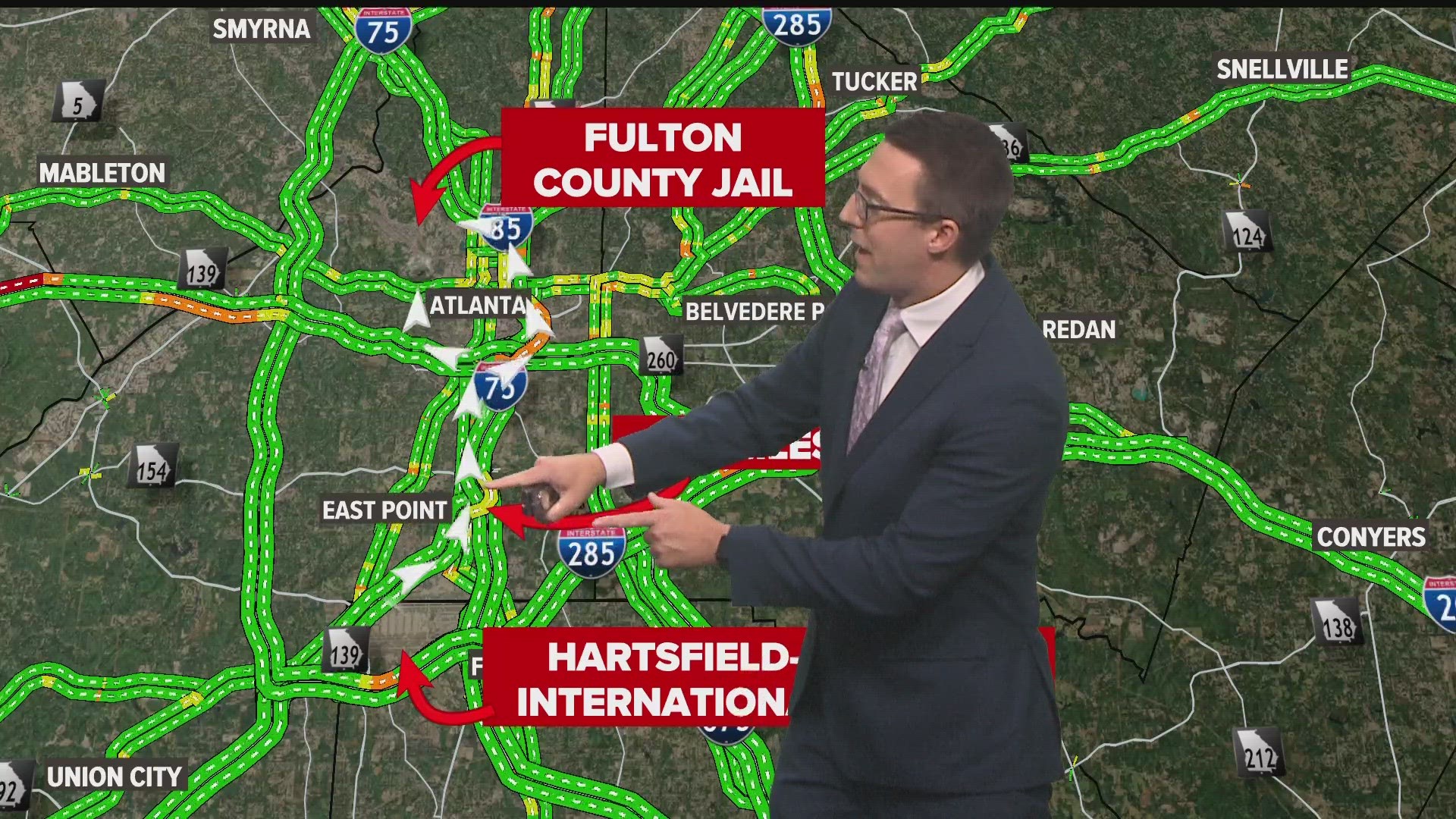
Amid the magnitude of Trump's booking, however, will still be the practical concerns of a regular Thursday for locals: Getting home through Atlanta's notorious traffic.
There are two major variables as of around noon Thursday as far as the traffic situation will go: It's not yet confirmed exactly when he will arrive, and of course we don't know which way he will go (with an important caveat thrown on top of that, which we'll get into).
With that said, here's a general sense of how to navigate things for Atlanta commuters:
Donald Trump in Atlanta | Traffic implications
- When he's coming?
Let's start with the easy part. We don't have an exact timeline, but we do know NBC News reported yesterday that Trump is expected to travel to Atlanta sometime this afternoon and surrender at the Fulton County Jail in the evening.
Of note, additionally, is that the FAA has a flight restriction above the Fulton County Jail for "VIP" from 6:45 p.m. to 9 p.m. (UPDATE: Trump said a little before 3 p.m. that he would surrender at 7:30 p.m.)
That means he'll probably impact at least some portion of rush hour. Best to plan for that.
- Which way he's coming?
UPDATE: Reports from the area suggest closures will be focused around Joseph E. Lowery Blvd, meaning Trump would likely arrive via either the first or third routes below.
UPDATE 2: The I-75/85 to I-20 West ramp is closed. Closures are also in place around Lowery Blvd. So it looks like the first route below is the route.
There are, essentially, two likely routes he takes coming from Hartsfield-Jackson Atlanta International Airport.
But first that caveat we mentioned - it's possible he goes somewhere else first instead of straight to the jail. There's no indication there's any plan for anything like that, but we can't rule out that it happens and scrambles the expected routes.
Another variable is that we don't know whether Trump will enter the jail complex on the Rice Street side or the Jefferson Street side, but that shouldn't really affect the broader overall route.
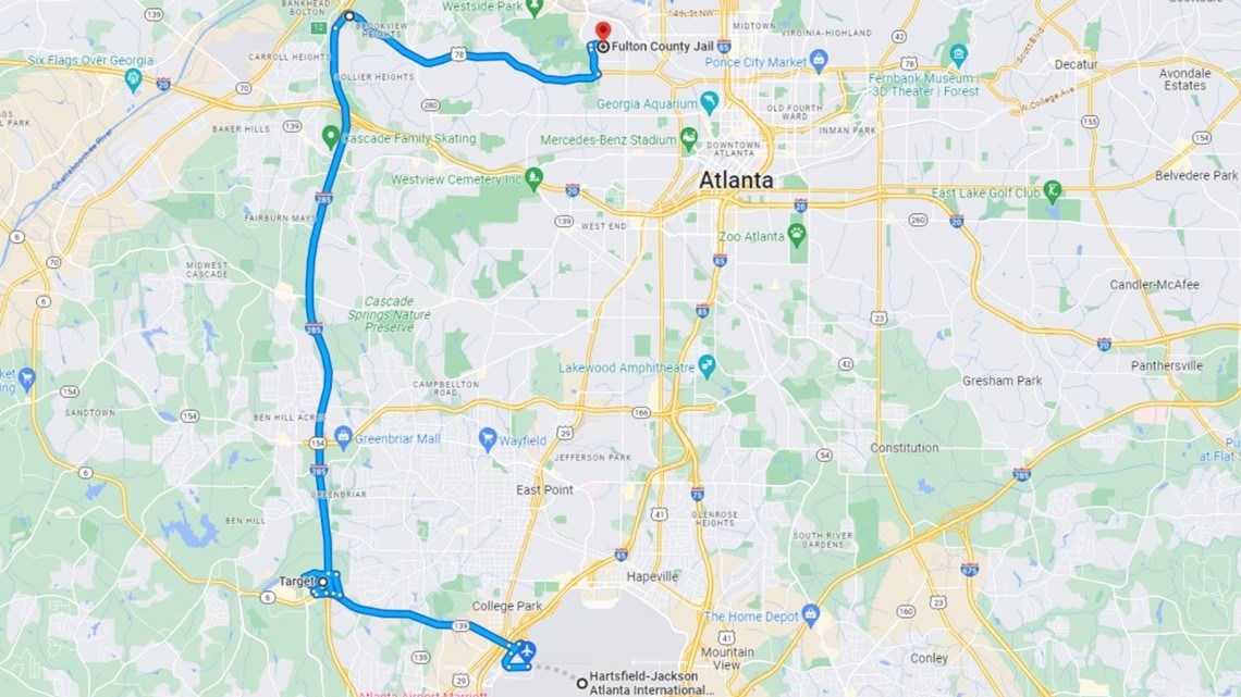
Acknowledging that possibility, the two likely routes - both about 14 miles in length - are:
I-85/75 to I-20
With this route, Trump would travel up I-85/75 to the point it meets I-20, then head on I-20 West to the Joseph E. Lowery Boulevard exit. Then he'd go about two miles up Lowery Boulevard to Donald Lee Hollowell Parkway (the old Bankhead Highway), go about a half-mile west, then take a right turn onto Marietta Boulevard to go up toward the jail.
This would result in closures on I-85/75, but not through any portion of the Downtown Connector, plus a portion of I-20 and then all of Lowery Blvd. running up to Hollowell Pkwy.

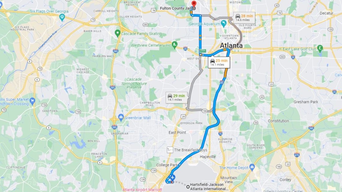
In the Google maps above, you can see the long stretch of Lowery Blvd. in the upper left portion of the route.
I-85/75 to North Ave.
Here, Trump would travel up to and past where I-85/75 meets I-20, go about two-and-a-half-miles around the Grady Curve, then exit at Linden Avenue, take a quick left onto West Peachtree Street, then take another quick feft onto North Ave.
He'd travel west on North Ave. until it runs into Northside Drive, and then go up to Hollowell Parkway to travel west a final mile before turning onto Marietta Boulevard.
This route would close both a critical portion of the Downtown Connector as well as major Atlanta surface streets - making it probably the more disruptive of the two main options.

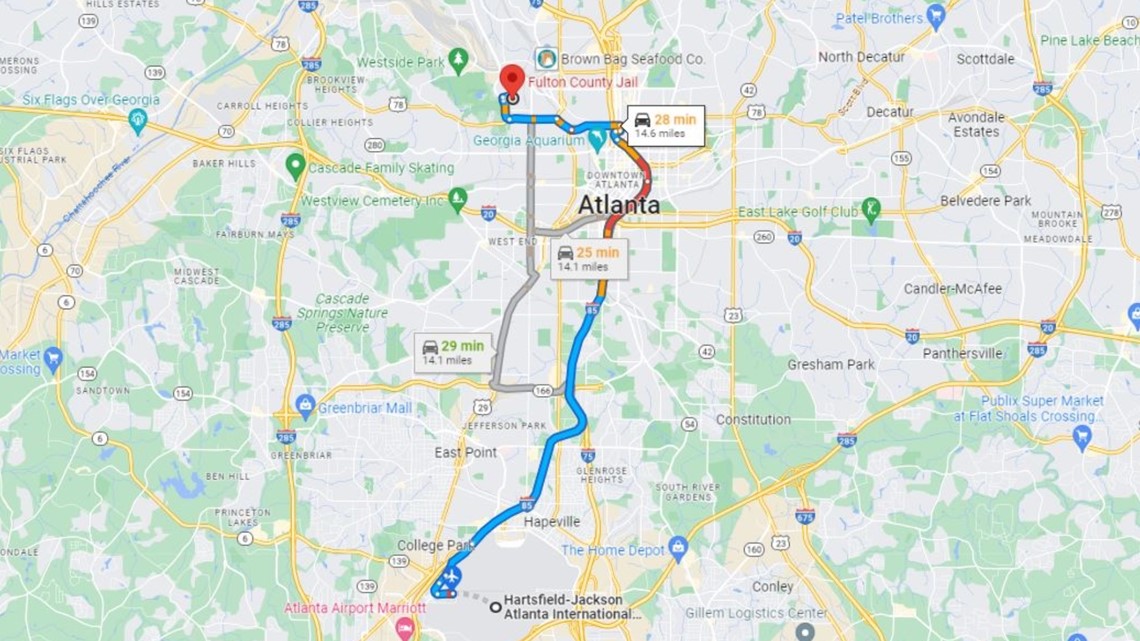
At the top of the route in the image above is where they would go around the Grady Curve, then start traveling west on Atlanta surface streets.
I-85/75 to Langford Pkwy.
This seems like more of a dark horse, because it would require a lot more time on surface streets than the other routes, but Google does suggest it as the quickest.
In this route, Trump would go up I-85/75, exit at Langford Parkway, go a short ways and then start traveling north on Lee Street near the Lakewood MARTA stop. This route would go up a couple miles to White Street, for a quick turn in front of the Monday Night/Wild Heaven/Best End brewery area, then up Lowery Boulevard three miles - crossing I-20 - to Hollowell Parkway.

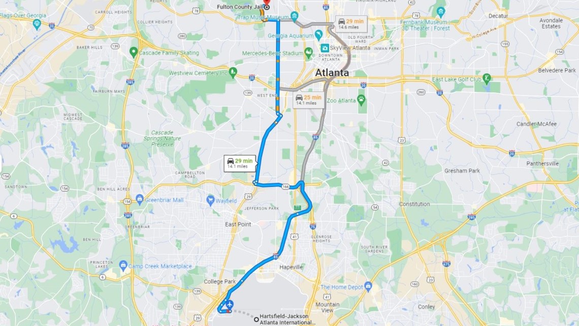
Above, you can see where this route splits off at Langford Parkway farther south than the other two.
I-285, the bonus dark horse route:
This is unlikely, because it would be the longest and slowest route, but it does offer the least amount of time on surface streets.
You could take Camp Creek Parkway from the airport about four-and-a-half miles to I-285, go 10 miles north to the Hollowell Parkway exit, and then go four miles east on Hollowell Parkway to Marietta Boulevard.
Again, unlikely, but it's a simpler route than the others.

You can see how that would kind of look above.
News happens fast. Download our 11Alive News app for all the latest breaking updates, and sign up for our Speed Feed newsletter to get a rundown of the latest headlines across north Georgia.