

ATLANTA — Although it hasn't felt like it for the first half of the month, the third quarter of the month will put the "Brrr" in October!
The coldest temperatures since April are here, and last through the rest of the week.
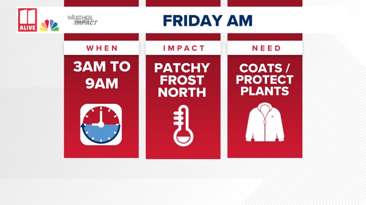
We are issuing an 11 Alive Weather Impact Alert for Friday morning again for the coldest air of the season so far. Although the cold will not be life-threatening, it will be a huge difference from the warmth we have seen for October so-far.
When: Friday morning from 3 a.m. to 9 a.m.
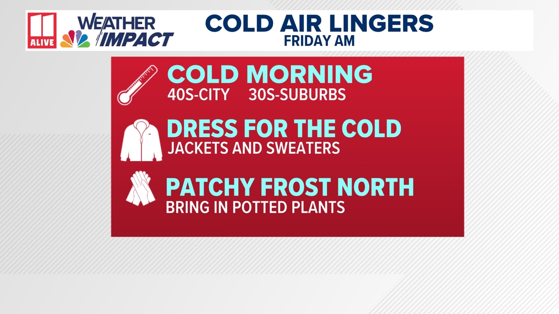
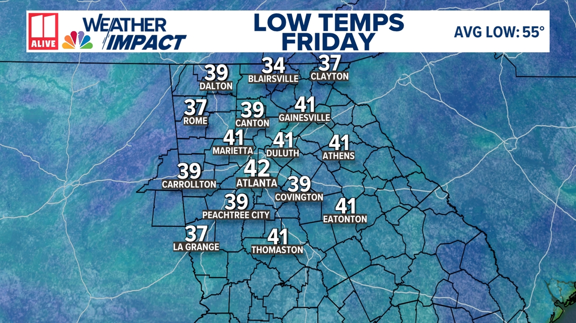
What: The coldest air since April. Lows in the 40s for the city. Lows will drop into the upper 30s in the suburbs. Low to mid 30s will be possible in the mountains.
Impact: You still need to dress for a cold start Friday morning. It won't be as cold Friday as it was Thursday morning. You'll need to protect sensitive plants that are more susceptible to the cold. Cover them with a sheet or bring them inside during these colder nights.

Why?
Canadian High Pressure moved in, and reinforcing cold air lingers for the rest of the week. This brings in a cooler air mass and lower humidity.
This week's cold will come with an extra dose of 'sticker shock' because of how unusually warm the first half of the month has been. To date, Atlanta is running about 4.6 degrees warmer than usual for the month.
How cold will it get tonight?
Although Thursday morning was the coldest of the stretch, Friday morning will still bring a very cold start to the day.
Temperatures in Atlanta area will fall to either side of 40 degrees. Colder temperatures will be felt elsewhere! Northwest Georgia could drop into the mid to upper 30s with some patchy frost. For the north Georgia mountains, low to mid 30s are possible.

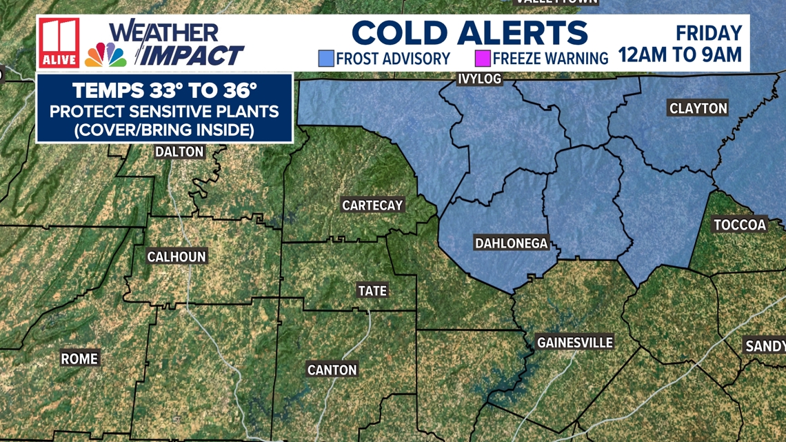
There is a Frost Advisory in parts of northeast Georgia. This includes Fannin, Towns, Union, Rabun, Lumpkin, White, and Habersham counties. This is where frost will be most widespread. Patchy frost is possible in other parts of north Georgia in the morning, but it will not be everywhere.

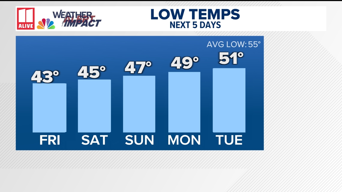
Morning lows the rest of the week
A gradual warming trend is on the way. Mornings will still remain chilly and below-average, but not as cold by the weekend.

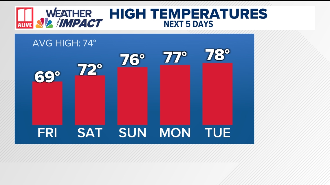
Cool but bright afternoons
Although each morning will be very cold, afternoons will warm up considerably with sunshine. Nevertheless, these will be the area's coolest "days" since April. To round out the week, afternoons will be in the low and mid-60s. By the weekend, the afternoons rebound into the 70s.
Light sweaters and jackets will remain in rotation for the afternoons, but you won't need the heavy coat for the entire day!

Is this Unusually Early to be this cold?
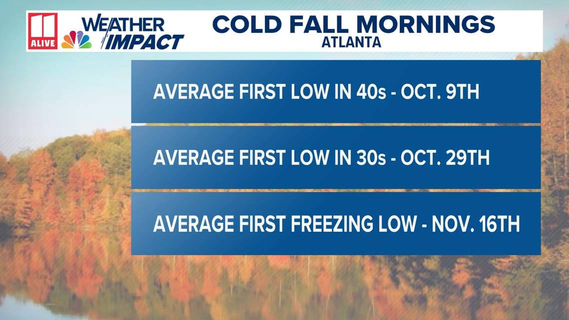
Although this a colder-than-normal period for us, it's not that unusual for Atlanta to see its first streak of sub-50 degree lows by mid-October. Atlanta averages its first morning in the 40s around October 9th, based on climatological data from 1991-2020. We typically don't see our first morning in the 30s in the city until the end of the month, around October 29th.
Atlanta typically doesn't see its first sub-freezing temperature until mid-November.

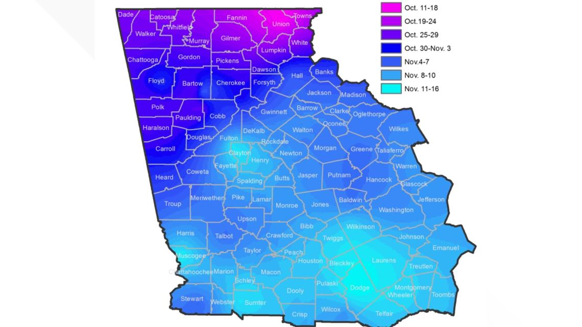
In the north Georgia mountains, mornings in the 30s are very common by the second half of October.
Based on data from the National Weather Service office in Peachtree City, many of our communities in Fannin, Towns, and Union counties average the third week of October for the first freeze of the season as well.
