ATLANTA — A disruptive winter storm will bring a wintry mix to parts of our area this weekend. We will be tracking an area of low pressure that will strengthen as it moves out of the northern plains into the southeast Saturday.
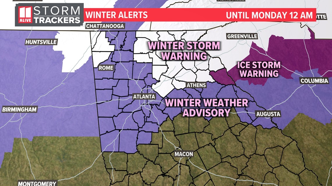
A Winter Storm Warning has been issued for Gwinnett, Forsyth, Barrow, Jackson, Chattooga, Fannin, Gilmer, Union, Towns, Rabun, Pickens, Dawson, Lumpkin, White, Habersham, Hall and Banks counties. In these locations up to 4 inches of snow is possible with up to a quarter of an inch of ice. For higher elevations in these areas, up to 8 inches of snow is possible along with ice. This will be coupled with strong winds. Expect difficult and dangerous travel and the possibility of power outages.
A Winter Weather Advisory spreads across the rest of the north Georgia down to Troup county and then along I-20 east of Atlanta. This includes Atlanta and several surrounding metro counties. In these locations a coating up to 2 inches of snow will be possible with up to a tenth of an inch of ice accumulation. The icing may be less in the metro but more than that in east Georgia closer to Athens.

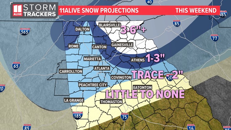
Snow Projections
For snowfall, we expect the highest accumulations in the North Georgia mountains. Locally there could be over 6 inches of snow. From Canton up through Gainesville, snow + sleet totals will be 1 to 3 inches on average. For the inner metro, down along I-85 south of the city and the I-20 corridor east, a slushy, mushy trace to 2 inches of snow + sleet is possible. Many will end up lower than that. Icing will be a bigger issue east of Atlanta. We do not expect any accumulations further south.
Remember, this is not a pure snow event. There will first be rain, then a wintry mix with sleet and freezing rain, and finally then a little snow. This winter slop makes the forecast a challenge.


The National Weather Service said that it has been 1,454 days since the last time their Atlanta site has seen measurable snowfall. That is the second longest streak on record, they said. Our last measurable snow occurred on January 18, 2018, nearly four years ago.
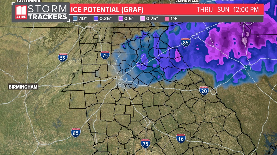
Ice Amounts
With our wintry mix including snow, sleet and freezing rain, there are multiple threats with this winter storm. For freezing rain: the highest ice totals will be along I-85 northeast of the city where totals could be up to a quarter of an inch. Around the metro a glazing up to a tenth of an inch of ice accretion will be possible, mainly on the east side of town. We expect some sleet on top of this but not included in these models below.

Impacts
The greatest impact potential will be northeast of the inner Atlanta metro, where significant travel disruptions are likely.
We have broken down the area into three zones: high, moderate, and low impacts.
For areas in Northeast Georgia, including the North Georgia mountains, Lake Lanier, and around the I-85 corridor, high impacts are possible. Likely accumulations of snow and/or ice will occur. We still do not know the final snow and ice amounts. Major travel disruptions are likely, including difficult and dangerous roads, even if treated. Power outages will also be possible based on the amounts of ice and wet snow coupled with gusty winds as the storm pulls away. There is a high confidence that this part of the state will have impacts from the storm and you should plan on staying off roads during the day Sunday and at least through early Monday morning.

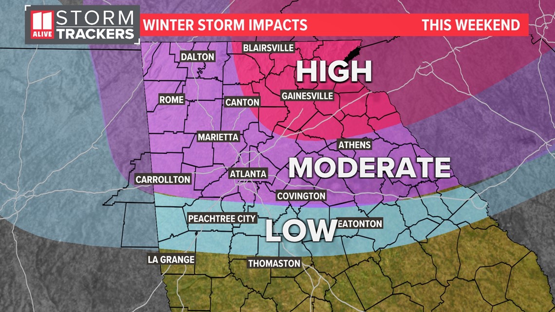
For the inner Atlanta metro area, the I-20 corridor and northwest Georgia along I-75, plan on moderate impacts. The wintry mix could cause travel disruptions. This forecast is ever-evolving as the final track and strength of of the cold is better known.
For areas well south of I-20, mostly rain is expect. Although you could see a little snow and/or ice, travel is not expected to be impacted.
Timeline
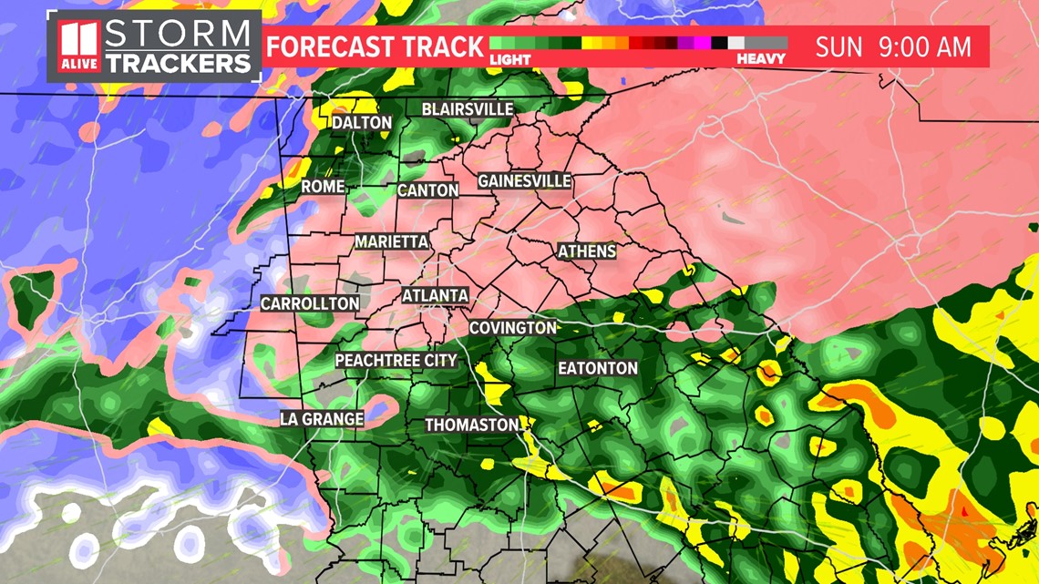
Sunday Morning
As the temps fall, a changeover to a wintry mix eventually takes place down in the metro area as the morning progresses.
Up in northeast Georgia a sloppy winter mess of snow and sleet has been ongoing for several hours with roads turning slushy, snow-covered and in some places slick.
By mid morning the wintry mix extends down into the metro. This mixture could be with sleet and freezing rain, as well as some flakes. Areas further south and west it may just be a plain rain at times, especially south of I-20. It will also be windy, with gusts 35 to 50 miles per hour.
The colder air starts to work into west Georgia later in the morning, starting the transition over to snow.

Sunday Afternoon
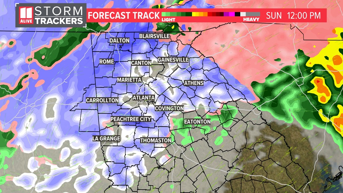
By Sunday afternoon, we quickly change over to all snow, even closer to the Atlanta area. Travel will be difficult northeast of the Atlanta area. Some slick or slushy roads are possible in the metro as well. Stay off the roads and let road crews do their job. It will be windy at times with gusts 25 to 35 miles per hour.

Sunday Evening
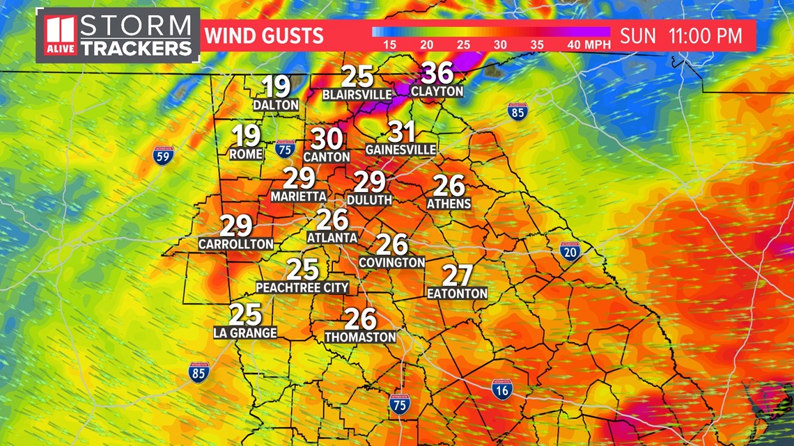
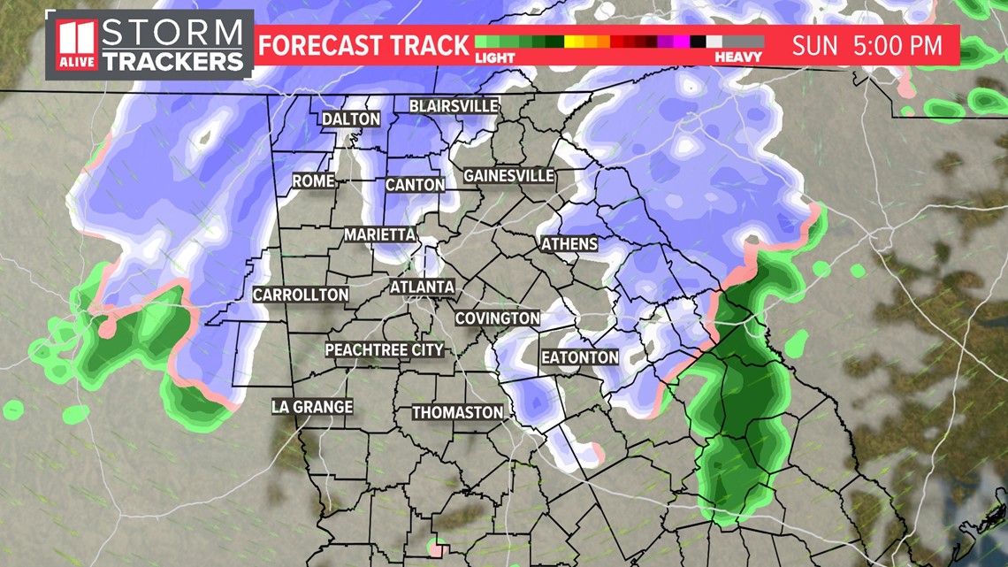
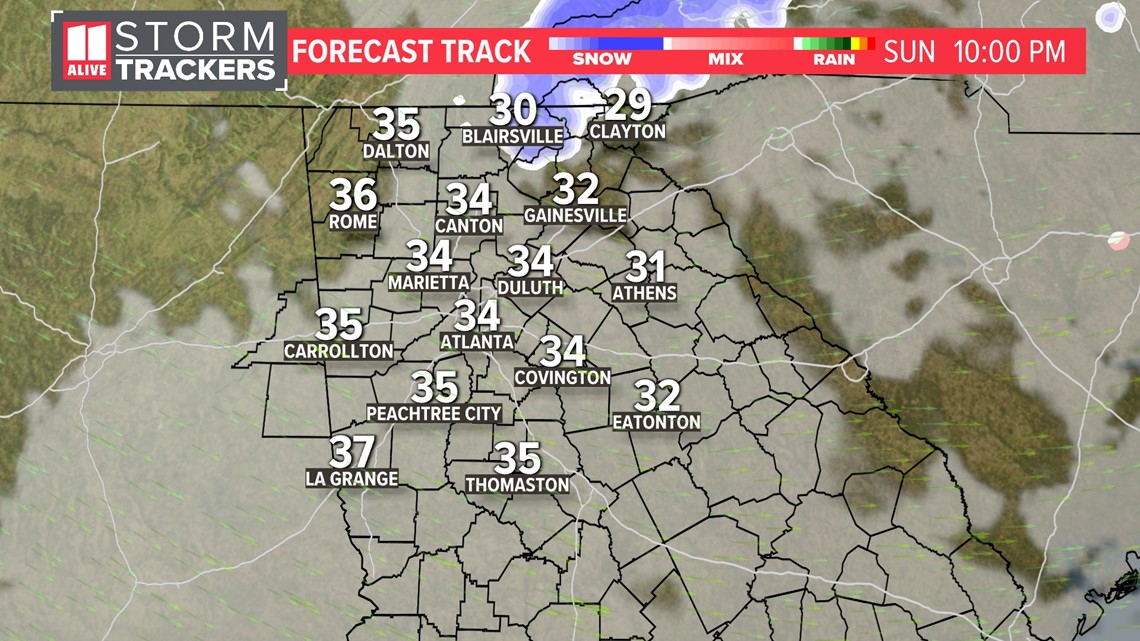
By Sunday evening, the snow starts to taper off as the low tracks away from our area and up the east coast. It will be windy with gusts 30 to 40 miles per hour. This will create higher concerns for power outages, especially in northeast Georgia under several inches of snow.

Sunday Night
Some snow showers or flurries may linger in the mountains but we dry out elsewhere. Temps drop back into the 20s and it will be windy. There could be gusts 30 to 40 miles per hour. We will be dealing with re-freezing and icy roads, as well as power outage potential in the aftermath. Power outages could be numerous in northeast Georgia where wet snow and some icing will blanket trees and power lines.

The Wind Factor
Not only will we be dealing with this winter slop on Sunday, but strong winds will also play a role in our power outage potential Sunday into Sunday Night.
Sunday morning as the low pressure works closer to our area, winds will gust 30 to 50 miles per hour

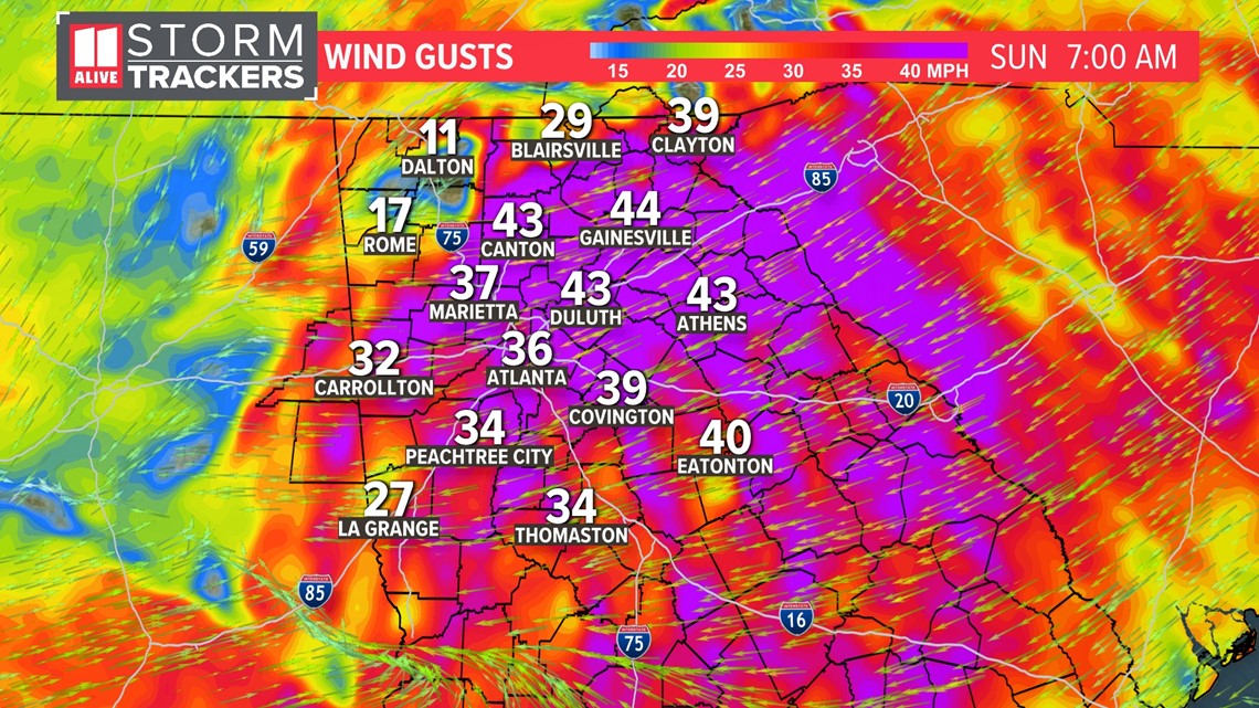
As the low pulls away Sunday evening and overnight, the winds will pick up again. This will peak our power outage issue for northeast Georgia where heavy wet snow will already be weighing down tree limbs and power lines. Power outages could be more widespread in far northeast Georgia where these strong winds gust in places with several inches of snow. The winds begin to lax later Monday

