
ATLANTA — Editor's note: This blog is no longer being updated. For the latest live blog, head here.
As Georgia turns its eyes to the Gulf of Mexico and the approaching Hurricane Helene on Wednesday, the metro Atlanta and north Georgia region is meanwhile already getting a downpour of rain.
The rain isn't related to Helene, but will saturate the region and set up exacerbated conditions for flooding as Helene tracks toward Georgia on Thursday.
Just about all of the area is in a Level 1 "Marginal" risk for severe weather, and we'll track any thunderstorm warnings that go out as well as the potential for flooding. Additionally, much of the region is under varying risk levels for excessive rainfall.
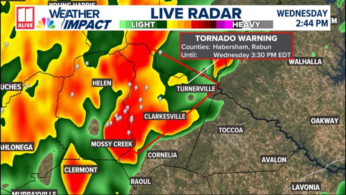
Around 2:45 p.m., Rabun and Habersham counties were put under a tornado warning to last until 3:30 p.m. That warning expired at 3:30 p.m., and the counties were then put under a severe thunderstorm warning that lasted until 4:00 p.m.
Metro Atlanta, north Georgia live weather updates ahead of Helene | Wednesday, September 25
11:15 p.m. | 11Alive's Cody Alcorn went out and surveyed the damage from storms across metro Atlanta and north Georgia on Wednesday-- days before Hurricane Helene arrives in Georgia.
7:02 p.m. | An image in Dunwoody shows a tree down at Drift Dunwoody on Dunwoody Park.
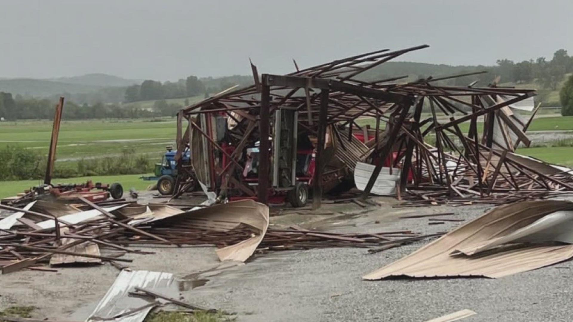
6:50 p.m. | Here's photo of a barn damaged in Habersham County Wednesday.
5:24 p.m. | Games 2 and 3 of the pivotal Braves-Mets series at Truist Park to decide one of the final spots in the National League Wild Card race have been postponed due to rain on Wednesday. The two teams will play a doubleheader in Atlanta on Monday -- one day before the MLB postseason begins.
4:04 p.m. | We are tracking the storms moving in ahead of Helene in metro Atlanta and north Georgia:
4:01 p.m. | The severe thunderstorm warning for Rabun and Habersham counties has expired.
4:00 p.m. | 11Alive's Crash Clark explained the major traffic backups happening across metro Atlanta with the heavy rains and flooding on Wednesday before Helene rolls through. As a resident in Sandy Springs, it usually takes him about 30 to 45 minutes to drive into 11Alive's station, but on Wednesday, he spent one hour and 15 minutes on the road.
Here's the full traffic breakdown:
3:58 p.m. | There are currently over 5,200 power outages across Georgia, according to the Georgia EMC map. There are more than 1,700 outages in metro Atlanta and more than 2,000 in north Georgia.
3:51 p.m. | 11Alive's Cody Alcorn received this photo of ping-pong-sized hail that fell in Habersham County during the tornado warning along New Liberty Road in Clarksville.
3:30 p.m. | The tornado warning in Rabun and Habersham counties expired, and the severe thunderstorm warning remains in effect until 4 p.m.
3:26 p.m. | All indications are that tornado warning is going to expire in a few minutes. 11Alive Chief Meteorologist Chris Holcomb reporting the rotation that triggered the warning has moved into South Carolina.
3:25 p.m. | Thankfully at this time, no reports of serious damage yet from the Habersham County emergency manager.
3:17 p.m. | Severe thunderstorm warning will be extended for Rabun and Habersham counties through 4 p.m.
3:15 p.m. | Hollywood and Turnerville along Hwy. 23 still the main area of concern here.
3:11 p.m. | Reminder that this warning is, at least for now, set to continue until 3:30 p.m.
3:08 p.m. | 11Alive Chief Meteorologist Chris Holcomb is highlighting where Talmadge Drive meets Hwy. 23.
3:06 p.m. | That rotation is now heading in the direction of Hollywood and Turnerville, with Tallulah Falls past that at the edge of the warning area.
3:05 p.m. | No confirmation of a funnel or touchdown, but 11Alive meteorologists are hearing of rotation with this tornado warning to the northeast of Clarkesville.
2:45 p.m. | Tornado warning issued for Rabun and Habersham counties until 3:30 p.m.

2:45 p.m. | Strong thunderstorms continue to roll through north Georgia, with White and Hall counties seeing some of it right now.
1:55 p.m. | Power outage in a busy intersection of Atlanta at Piedmont and Cheshire Bridge:
1:55 p.m. | North Georgia State Fair closing for today and tomorrow:
1:20 p.m. | Polk County emergency services reports trees and wires down near Treat Mountain Road and Cup Lake Road.
In addition, Floyd County emergency services reports standing water in much of Rome.
1:20 p.m. | 11Alive's Cody Alcorn passes along these pictures of flooding in Bartow County.
1:15 p.m. | Clayton County Public Schools canceled athletic events for today and tomorrow due to the weather.
1:10 p.m. | NWS reporting rainfall in this area south of Chattanooga and into Alabama has already seen 2-2.5 inches of rain, with Helene of course set to bring a lot more through Friday.
12:45 p.m. | Strong thunderstorms are rolling through western counties including Paulding, Haralson, Carroll and Douglas.
There were earlier strong thunderstorms farther to the northwest including in Floyd, Gordon and Bartow counties. There was a severe thunderstorm warning for Floyd, Bartow and Polk counties about an hour ago.
12:40 p.m. | The National Weather Service has put out an advisory that a portion of northeast Georgia is in a "High" risk for excessive rainfall. Much of inner metro Atlanta is in a "Moderate" risk as the "High" risk zone applies to some of Gainesville and the northeast corner of the state.
You can see a closer look at the map below at the NWS link here.